

Bushfire Planning
Bushfire Planning Requirements
If your property is in a Bushfire Management Overlay (BMO) and you need a planning permit to build or subdivide, you'll need a Bushfire Management Statement prepared by an accredited consultant. That's where we come in.
We are Bushfire Planning and Design (BPAD) accredited bushfire consultants with 15+ years of planning experience. We prepare the reports councils and the CFA need to assess your application — clearly, accurately, and without unnecessary delays.
The BPAD accreditation scheme is managed by the Fire Protection Association of Australia (FPAA). They are the technical and educational fire safety organisation within Australia that recognises practitioners as providers of professional bushfire assessment, planning, design, and advice services.
What We Prepare
-
A detailed written assessment required for planning applications in the BMO. It addresses the three key requirements of Clauses 44.06 and 53.02 of the Victorian Planning Scheme: a bushfire hazard site assessment, a bushfire hazard landscape assessment, and a written statement demonstrating how your proposal responds to the identified risk.
-
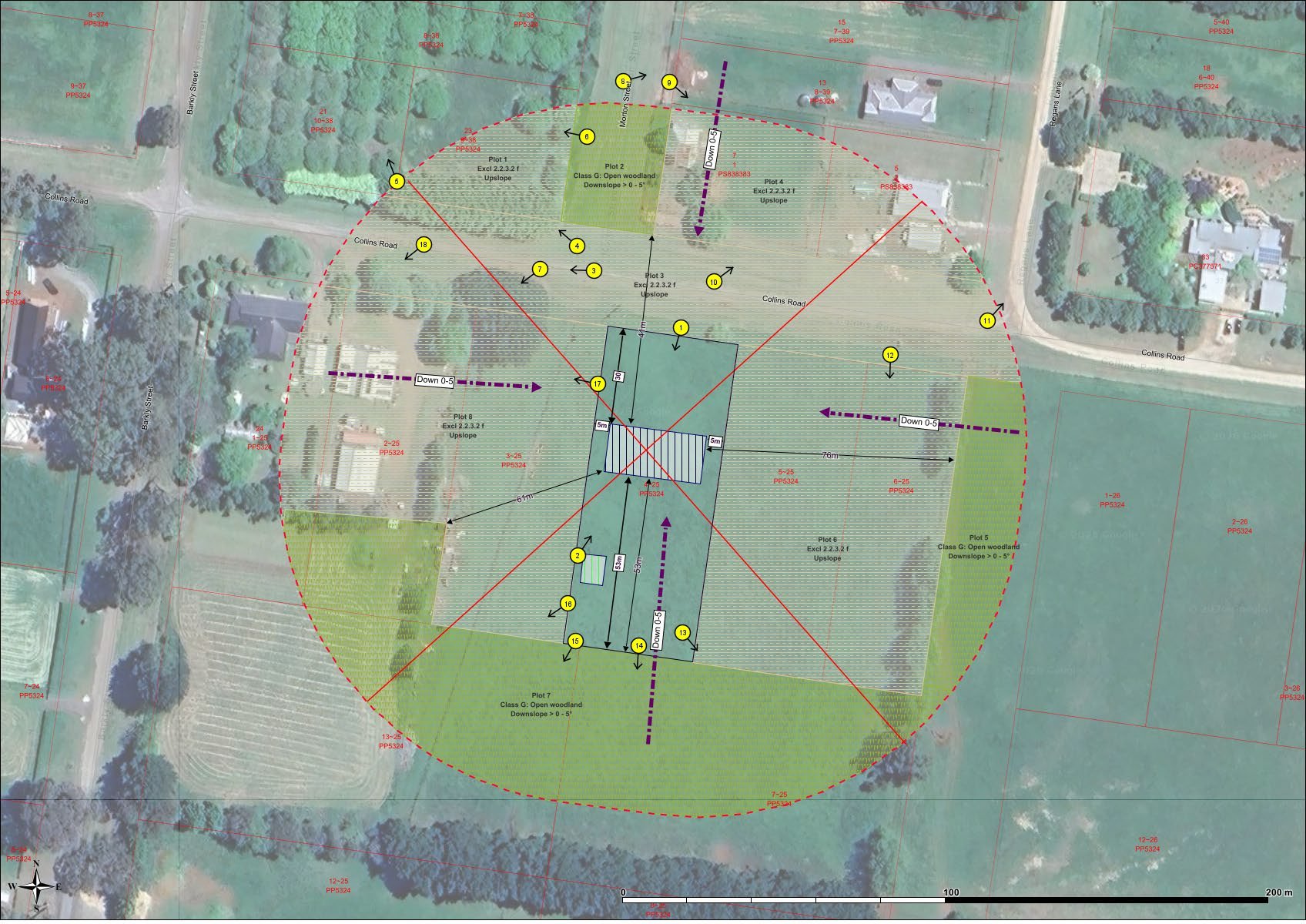
A scaled site plan that accompanies the BMS. It visually shows how bushfire protection measures will be implemented on your property — including defendable space, vegetation management zones, access arrangements, water supply locations, and construction requirements.
-
If you also need a building permit, we can prepare your Bushfire Attack Level (BAL) assessment at the same time, saving you time and avoiding the cost of engaging a separate consultant.
What You Receive
When we complete your bushfire planning assessment, you receive:
A professionally prepared BMS meeting council and CFA requirements
A scaled BMP site plan
A BAL rating determination
Ongoing support to respond to any council or CFA queries through to approval
We visit your property to assess the site first hand — vegetation type and density, slope, access, water supply, and the broader landscape context. We don't prepare reports from a desk.
Do You Need a Bushfire Management Statement?
You'll likely need a BMS if:
Your property is in the Bushfire Management Overlay (BMO)
You're applying for a planning permit to build a new dwelling
You're subdividing land in a bushfire-prone area
Your council or the CFA has requested one as a referral condition
Not sure whether your property is in the BMO? Call us on 0400 081 073 and we can check for you in a few minutes.
Understanding the Key Terms
Bushfire planning involves a lot of acronyms. Here's what they mean in plain English.
Bushfire Prone Area (BPA)
Bushfire prone areas (BPA) are where the bushfire hazard has been identified and mapped under the building system. These areas are subject to or likely to be subject to bushfires. This triggers building permit requirements where new buildings are required to build to a national bushfire construction standard. This is known as a bushfire attack level (BAL).
Bushfire Management Overlay
The bushfire management overlay (BMO) applies to land that may be significantly affected by extreme bushfires.
A planning permit is required for some types of development to ensure bushfire risk is considered and bushfire protection measures are in place.
Bushfire Attack Level (BAL)
A bushfire attack level (BAL) is a way of measuring the severity of a building's potential exposure to ember attack, radiant heat and direct flame contact.
Bushfire Management Statement (BMS)
A bushfire management statement is a detailed written assessment required for planning applications in the Bushfire Management Overlay (BMO). If your property is in the BMO and you need a planning permit to build or subdivide, you'll need a BMS prepared by an accredited bushfire consultant. A BMS addresses the three application requirements of Clauses 44.06 and 53.02 of the Victorian Planning Scheme:
Bushfire Hazard Site Assessment - an assessment of the bushfire hazard on and around your property
Bushfire Hazard Landscape Assessment - a broader assessment of the bushfire risk in the surrounding landscape
Bushfire Management Statement - a written statement demonstrating how your proposal responds to the identified bushfire risk
Bushfire Management Plan (BMP)
A bushfire management plan is a scaled site plan that accompanies the BMS and visually shows how the bushfire protection measures will be implemented on your property. This includes defendable space, vegetation management zones, access arrangements, water supply locations, and construction requirements.